SCANZ2013: Crossing borders – identity, culture and place

29 01 2013

On Tuesday we had an excellent workshop where the topic was focused on ‘crossing borders’ and what that meant in terms of negotiating different scenarios. The speakers came from a range of perspectives including a Māori leader, scientists, and people who have worked extensively with Indigenous peoples.

One of the things that has really been powerful for me is how Māori people identify people they meet. When you meet Māori the way you introduce yourself is through where you come from (where you were born) and your ancestors. This is very different to a European or ‘western’ way of knowing a person, say through their qualifications, work and academic achievements. For me, the connection to place as informing identity and ‘meeting’ each other, offers a rich possibility for linking and sharing experiences.

A lot of my work as an artist over the years that been an exploration of ‘where’ and ‘how’ I fit, in terms of a relationship to land and place, especially in the Fauxonomy project. But even when I was working on Big Banana Time Inc, there was a need to discuss issues around place and identity within an appropriate context, given my ‘bitza’ migrant heritage. In many ways I have struggled with this question of ‘where’ I am from, in terms of a sense of belonging. I often tell people that I was born in Brisbane, brought up in Darwin and since then have lived in Victoria, Sydney and now Canberra. In terms of where I felt ‘connected’, I always think of Darwin, the countless hours I spent walking on the rocks at Nightcliff beach, and I still have dreams of diving off the rocks into the tropical waters of the Timor Sea. It was the place where I witnessed the power and beauty of nature, through monsoons, sweltering humidity and lush vegetation. The stars were like an enormous sparkling blanket and I realised as a child that humanity is such a small part of the story of nature.

Lightning Over Nightcliff Beach, 14 Nov 2010 by Andrew Brooks

Lightning Over Nightcliff Beach, 14 Nov 2010 by Andrew Brooks

The problem (in my mind) with claiming a place as ‘where’ I am from is a direct result of my migrant background. By living in Darwin and going to school with kids from remote communities all of the Northern Territory, I learnt that in Aboriginal cultures there is a wholistic connection between land, spirit, language and identity, that manifests in ritual, art, song and performance – as all of these elements are connected. In ‘western’ culture all of these elements have been described and located into separate compartments, called ‘disciplines’. Anyway, that is a much bigger topic that I won’t get into here…

I have been considering ‘where’ I am from and have had some very rich conversations around this topic with other SCANZ residents. When I think about it, I wasn’t actually born in Brisbane, I was born in Redcliffe, about 30 kilometres north of Brisbane. It was the original site of the colony of Brisbane, which was later disbanded for the current site of the city. Mr Wikipedia says:

Before European settlement, the Redcliffe Peninsula was occupied by the indigenous Ningy Ningy people. The native name is Kau-in-Kau-in, which means Blood-Blood (red-like blood).

Redcliffe holds the distinction of being the first European settlement in Queensland, first visited by Matthew Flinders on 17 July 1799. Explorer John Oxley recommended “Red Cliff Point” – named after the red-coloured cliffs visible from Moreton Bay – to the Governor Thomas Brisbane for the new colony, reporting that ships could land at any tide and easily get close to the shore. The party settled in Redcliffe on 13 September 1824, under the command of Lieutenant Henry Miller with 14 soldiers, some with wives and children, and 29 convicts. However, this settlement was abandoned after one year and the colony was moved south to a site on the Brisbane River at North Quay, 28 km (17 mi) south, that offered a more reliable water supply. For more information on Redcliffe’s history see http://www.redcliffehistoricalsociety.com

Redcliffe became a pastoral district in the 1860s and in the 1880s boomed as a seaside resort town with the paddlesteamer Koopa making regular trips to its jetty from 1911.

Postcard from Redcliffe

Postcard from Redcliffe

When we moved back to Brisbane from Darwin, I had huge issues adjusting to the culture and environment of Brisbane, I was extremely unhappy and became very rebellious, causing my parents more than their share of grief. One of the ways my parents would cope would be to send me to my Godmother, who lived in Redcliffe. When I would visit her, we would go for long walks along the coast and swim, and in many ways, when I think back, it was very healing for me to be near the sea.

Redcliffe

Redcliffe

So considering all of this, perhaps I need to explore and identify more with Redcliffe as the place I am from, or at least try and find and build the connections. In Māori introductions, you invoke your mountain, your river and your ocean. My mountain is Clear Mountain, my river is the Pine River, which snakes through northern Brisbane, though Aspley where I lived as a child and my ocean is the Pacific, deep and blue.

References 

Fauxonomy links

Postscript: I just noticed on Facebook that Redcliffe celebrates Waitangi Day – synchronisity!


Walking on Mt Taranaki – Maketawa Hut

28 01 2013

On Saturday a small group of SCANZ residents (incidentally all Australians) got together and did some bushwalking on Mt Taranaki. This was an important part of my project for SCANZ as the artwork I have made for the exhibition at Puki Ariki focuses on aerial maps of the mountain. I needed to have an understanding of the terrain and the vegetation that was ‘felt’, not just observed.

It was probably one of the most beautiful walks I have been on for a long time and one of the most physically challenging. As we walked from the Visitor’s Centre, we headed up to the three way turn off to the summit walk, then headed towards Maketawa Hut for lunch. The first part of the walk was walking uphill along a series of ridges, with beautiful views of the valley below and the coastline. Mt Taranaki however was hidden under cloud so we were not able to see the summit.

Around the mountain circuit - from Dept of Conservation website

Around the mountain circuit – from Dept of Conservation website

(From http://www.doc.govt.nz/parks-and-recreation/tracks-and-walks/taranaki/taranaki/around-the-mountain-circuit/)

After lunch we started to head down the track, through what I can only explain as an enchanted forest, with tree roots in many parts acting as natural steps. Once we arrived at the lowest point above sea level, we then went up and down some steep ridges and creeks. I found the landscape was both gentle in its beauty but difficult in terms of traversing. Along the way were a number of ladders up and down, giving a real sense of the undulating land formed by lava so long ago.

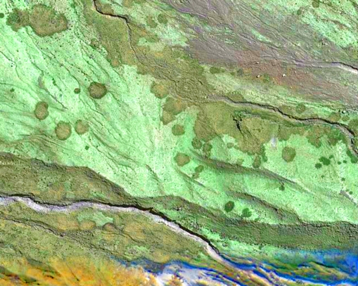
It was also wonderful to see elements of the imagery that I had collected of aerial views in the landscape. For example, these beautiful shapes in the image below.

Mt Taranaki

Mt Taranaki (from ‘Message to the mountain’ 2013)

Here is some information about the walk we did from holidays in New Zealand website (note we did the walk in the opposite direction):

Maketawa Hut Round Trip – 4 hours

This is for those who are fitter. Take the Ngatoro Track from below the Information Centre and turn left at the Maketawa Track Junction.

This takes you through more mossy forest, changing to nikau, cordylines and other flora and fauna. It takes about 2 hours to Maketawa Hut.

Walk through the hut to the outdoor deck for extensive views. Leaving the hut you walk up through alpine vegetation………….steps…steps… and more steps! Eventually you come out on the road just below the Translator Tower. From here you walk back down the road to the Camphouse.

One of the things I have learnt about mountains in Māori culture is that they are like people being male or female.  In an earlier post I discussed the story of how Taranaki came to reside in this region. Something else, I found very interesting is that in Māori culture, one should avoid touching the top of the head as it is the centre of all knowledge and memory. For this reason, it is not culturally appropriate to climb to the top of the summit and ‘stand’ on someone’s head. To learn some more about cultural protocols go to http://www.headspace.org.nz/maori-mental-health.htm.

A special thank you to Jo Tito for reviewing this post.


Contemplating SCANZ2013 Themes – Revisiting Scalpland

24 01 2013

scalpanim

One of the things I have enjoyed most so far about the residency is the diversity of artists and art forms included in SCANZ. I have particularly loved the strong links between art, the environment and Indigenous knowledge. A powerful theme that has resonated is the connection between land and body – not being separate entities but coexisting and connected. This is strong in many Indigenous cultures and we have learnt so much over the last week, through the generosity of the Māori people involved in the residency and the people we have met through them, in particular Jo and Terri.

This relationship between land and body, especially articulated through performance and song has reminded my of one of my earliest works addressing land, body and identity – Scalpland.

This ‘poetic performance’ involved me clippering my hair off, using my head as a metaphor for land development and as a way of challenging feminine stereotypes of beauty and conformity by using the pseudo science of phrenology to highlight the perpetuation of assumptions derived from physical appearances. It was also a means to address a singular notion of history, one that was written onto the land by ‘clearing the surface’ and erasing the stories and histories that had gone before. Essentially this work was a response to the changes I witnessed returning to Brisbane after ten years away and the sense of loss I experienced.

When I returned in 1993, I did not recognise my old neighbourhood, the creek I played in as a child was now under a four lane highway, the bush where we made humpys (pretending we were Aborigines) was turned into retirement villas and my street was now a dangerous, major arterial road. It had become polluted and ugly, a place where traffic pollution was endemic and seemingly devoid of a community ‘heart’.

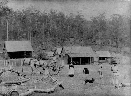
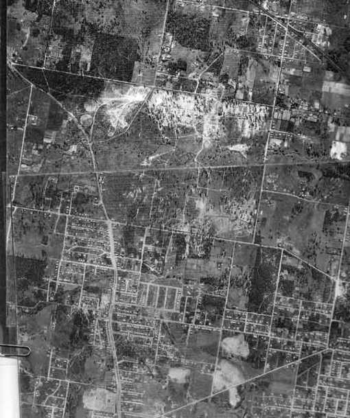
As I reflected on this work at SCANZ, I decided to do some research and came across some interesting historical images and maps. The picture below shows the site of Aspley State School, about 200 metres from home (on my street Maundrell Tce), before it became a school.

Aspley 1887 - site of Aspley State School

Aspley 1887 – site of Aspley State School

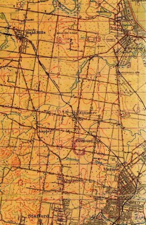
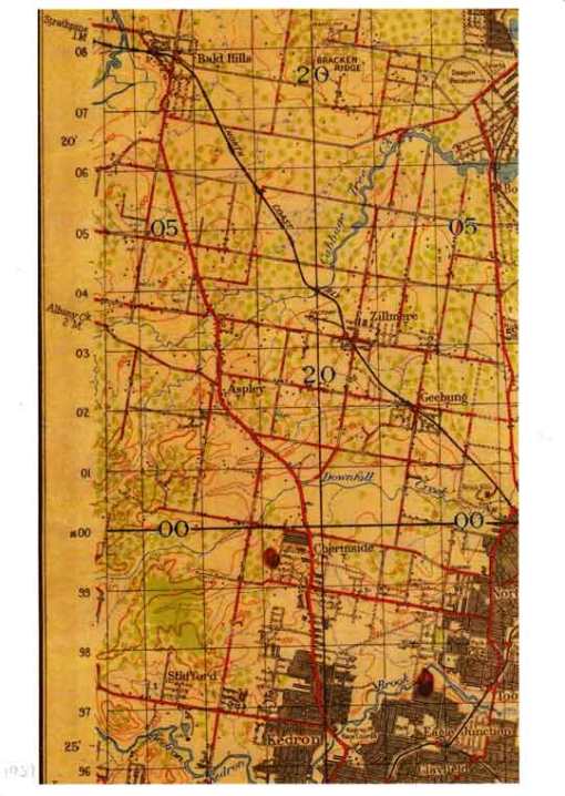
Here are some early maps, including an aerial map from 1946.

1925 Chermside and District

1925 Chermside and District

1937 Chermside and District

1937 Chermside and District

Chermside1946 Aerial

Chermside 1946 Aerial

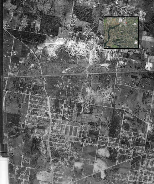
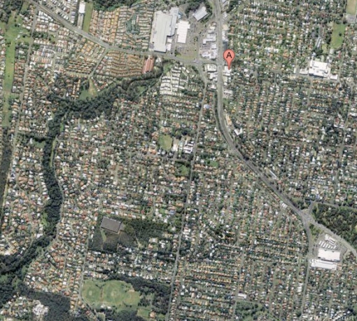
In this image I have placed a current aerial map over the 1946 map to highlight the change, the close up follows after the next image.

Chermside-1946-Aerial_540-old-and-new

Chermside District 2013

Chermside District 2013

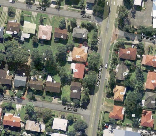
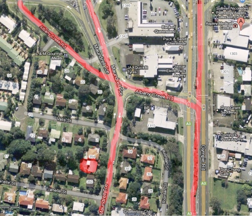
This shot is a much closer view of my block

Maundrell Tce 2013

Maundrell Tce 2013

One of the very interesting things I found out was that Gympie Road and Albany Creek Road were Aboriginal tracks. The creek where I played as a child was a meeting place and crossroad for potentially tens of thousands of years. Mr Wikipedia states:

Soon after Brisbane was declared a free settlement in 1842, people began exploring the lands north of Brisbane City. A northern route followed aboriginal tracks through what is now Kelvin Grove, Enoggera, Everton Hills, Albany Creek onto North Pine. This route is still known as “‘Old Northern Road'” and “‘Old North Road'” in places.
Another aboriginal track branching eastward from the Old Northern Road at the South Pine River crossed towards Little Cabbage Tree Creek and continued towards Downfall Creek. This track is now known as “Albany Creek Road” and “Gympie Road”. Albany Creek Road was known as “Chinaman Creek Road” before 1888.

Here is a map of where the tracks used to be, the line in the centre is Maundrell Tce (my street) with my house highlighted. Please note that Maundrell Terrace was NOT a track.

Ancient Tracks

Ancient Tracks

At this stage of my life, the idea of shaving my head is not very palatable (it takes too long to grow back), but I am really interested in exploring this piece on some level again, not sure how, but my time here at SCANZ has certainly reinvigorated my thinking about body/land/history/knowledge in an immediate way.

Check out these websites for more information:
http://queenslandplaces.com.au/node/39
http://www.chermsidedistrict.org.au/chermsidedistrict/default.asp

This post was also published on http://remotexmedia.wordpress.com


SCANZ2013 Update

23 01 2013

It was my intention to publish a blog every day we were here at the SCANZ2013 residency, but it has been so busy and I have been so immersed in the residency workshops, meetings and conversations that time has slipped away.

The residency formally started on the 20th January, but many people arrived a few days earlier. People who did come earlier were encouraged to go with the group to visit Parihaka, a Māori community about 50km south of New Plymouth. These visits coincided with monthly ‘days of observance’ where on the 18th and 19th of every month, people meet at the marae (meeting place) to acknowledge the historically significant events that occurred between 1860 and 1900.

The Parihaka website states “It is still the meeting place of the peoples of Te Whiti o Rongomai and Tohu Kākahi. The 18th day of every month is still the pivotal forum of the community wherein the traditions and teachings of Parihaka are maintained. The spiritual legacy is one of living in harmony with the land and humanity. It is also a legacy of nonviolent resistance action and a belief in the peaceful and respectful co-existence of Māori and other races.”
For more information, go to http://parihaka.com/.

On the journey to Parihaka, we all learnt a song, which is now embedded in my brain forever. Here are the words:

Te Aroha
Te Whakapono
Me te rangimarie
Tātou, tātou e

The translation (hugely simplified as one word has many meanings and implications in Māori):

Love
Faith
Peace
For us all

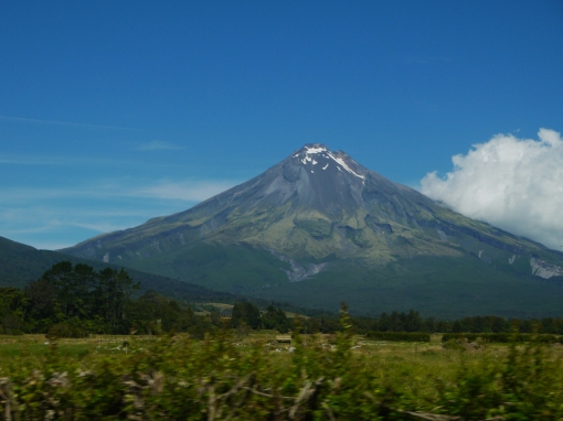
Such beauty in meaning! As we traveled to Parihaka, Mt Taranaki loomed majestically above us, although the view was not clear as it is in this image below.
2013_0122CU

It was an experience that was humbling and overwhelming. As we proceeded into the house where the meeting was happening, we exchanged hongi (a traditional Māori greeting, where you press noses). We then sat around in a circle, where a number of people spoke and sang in Māori. I think the initial speakers were elders. Although I didn’t understand the language, I sensed that there was a lot of focus on remembering the past and its connections to now, family and some community business. At a certain point the conversation then was predominately English, and we were invited to introduce ourselves. I was very nervous, and when I announced that we were Australians, there was a bit of laughter, as my accent gave me away, lessening my nerves. I don’t wish to go into too much more detail of the meeting except to say it was a very welcoming and open environment, where although there were structures around who spoke when, everyone had a voice…

After the meeting, we all gathered in the community hall and had a delicious lunch, prepared by the community, relaxing and getting to know each other.

Here is a picture of the group, image by Ian Clothier.

SCANZ group at Parihaka

SCANZ group at Parihaka, image Ian Clothier

That evening all the artists gathered again to participate in a whakawhanaungatanga, a traditional way of introduction where we focused on three things – our identity and heritage, our impressions of Parihaka and what we wanted to achieve at SCANZ. It was a really great way to get to know each other, and draw out some interesting linkages and connections, between our identities and foci as artists.

It was an amazing day, which for me was a great introduction to SCANZ and the place and people of Taranaki. More coming soon!

I would also like to give a special thank you to Jo Tito for helping me with this post.


Free and open online learning

23 01 2013

As many of my readers are well aware, I have a love of the Internet as an open and accessible space – which is why I love open source software and web accessibility standards (WCAG).

More recently I have noticed a number of excellent resources for online learning  – for free! For example, the Open Education Database has a broad range of courses from universities from the United States, including Berkley, National University and The Art Institute Online.

Another great resource for free education online is Coursera, where I have recently enrolled in a course focused on Social Network Analysis.

Another example, especially for webbys is the  P2PU / MOzilla WebCraft project, where you can not only learn, but contribute as a tutor an educator.

It is really heartening to see that despite the tightening up of a lot of online resources (eg. music, news media), that open culture is growing and thriving.

I am keen to build a list of great examples on mediakult, so please let me know if you see good courses.